Solution for geocoding of Czech and Slovak addresses
GeoMarker Pro is the premier tool for accurate geocoding (filling XY coordinates) and address validation including manual tracing. Together with the program MapInfo Pro provides an excellent combination for sales and marketing data analysis and allows database systems to store the address data cleaned and validated.
- Automatic address geocoding
-
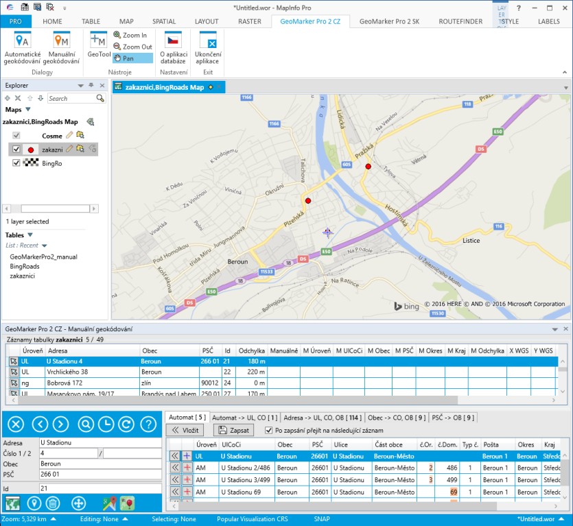
Geocoding is the process whereby the database records are assigned the XY geographic coordinates based on the address. GeoMarker's automatic mode allows you to perform this operation in bulk. The result is the creation of a point map layer with which the user can work in GIS applications, such as performing geographic analyzes of customers, optimizing the routes of sales representatives, etc. Each entry displays the code of the achieved level of location and the maximum deviation of the point in meters.
- Addresses checking and correcting
- In addition to custom co-ordinates, the input addresses are checked during geocoding. The new output columns will then fill in the official names of the individual parts of the address, or fill in entries that were missing on the entry (eg part of the municipality, second house number, postal code, etc.).
- Manual geocoding and search function
- For records that could not be placed with sufficient precision, you can use the manual geocoding feature. The user offers options for the solution, or the user can manually record the map exactly to the location of their choice. The "Find" feature allows you to quickly find an address and display it on a map.
- Geocoding algorithm
- The application uses a sophisticated algorithm that can handle some aspects that have a significant impact on geocoding quality. This is a series of Czech specifics for entering addresses, typos, non-code postcodes with administrative breakdowns, etc. The GeoMarker Pro application is delivered in the Czech language version, in the version for geocoding of Czech and Slovak addresses.